Basic mapping concepts
Before you begin making a map, you should understand some basics.
Basic Concepts
Latitude & Longitude
Basic Map Elements
Title
Direction
Spatial Scale
Time Scale
Legend
Cartographer
Date of production
Latitude & Longitude
To find an exact location on a map, what do you need? Crossing lines that create an intersection make a grid system so you can find anything, anywhere! One grid system is used by mapmakers all over the world. It helps you find any place on Earth. It is known as latitude and longitude.
Title
The title is one of the most important parts of a map. It gives the viewer an idea of what the map depicts.
Direction
Every map should have North arrow to demonstrate the map's orientation. The question of what is north can be an issue on some maps. On the earth, true north (the direction to the North Pole) isn't exactly the same as magnetic north. Most maps we compose are oriented to true north, even though compass readings in the field are angled to the magnetic pole.
Spatial Scale
How close should we get? How much detail do we need? How accurate is this map:
We use maps of different scales to answer different questions.
Scale is the relationship between a distance portrayed on a map and the same distance on the Earth.
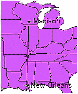
To find out how far apart New Orleans, Louisiana and Madison, Wisconsin are, we do not get out separate maps of Wisconsin, Illinois, Missouri, Tennessee, Mississippi, and Louisiana and then lay them together like puzzle pieces on the floor to measure the distance. That would take a lot of work and space! Instead, we get out a single map of the United States (or, in this case, a map of a portion of the U.S.).
 Or, if we tried to make one map of the streets of all of the cities of the United States either the lines would be so tiny that we couldn't see them, or the map would be so big that it would be impossible to unfold in your room! We need separate, detailed maps of each city so we can see all of the streets and their names and figure out the best route from one part of the city to another.
Scale is important! To understand scale there are a few things you need to learn.
1. Map scales are unitless.
A scale of 1:1,000 means for every one unit on the map, you would need to measure one-thousand of those units on the earth. So 1 cm on the map represents 1,000 cm on the ground and 1 mile represents 1,000 miles at this scale.
An example of a scale used on a map:
2. A large scale map shows details.
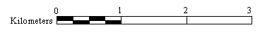
1:4,081—A large scale map of Madison's State Capitol Building
A map under 1:40,000 is considered large scale. These include city maps and building construction plans.
3. A small scale map is more general and shows large regions.
1:204,324—A small scale map of part of Dane County
A map over 1:100,000 is considered small scale. Maps of counties, states, countries, or the World are considered small scale.
Confused? Here's a Hint!
To remember large vs. small scale, think of the numbers as fractions.
- 1/10,000 (large scale)
is larger than
1/100,000 (small scale)
The small scale map (1:100,000)
shows more area
than the large scale map (1:10,000)
 For Example...
On a small scale map, everything looks small—like you are high up in an airplane.
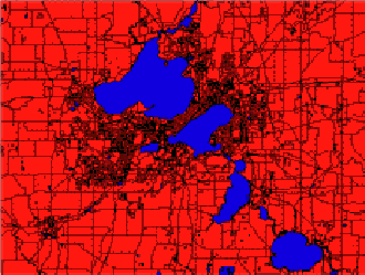
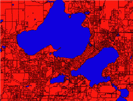
1:100,965 —A small scale map of Madison. What are the names of the Madison Lakes?
 But on a large scale map, you get closer to the earth, and everything looks larger!
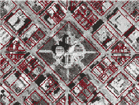
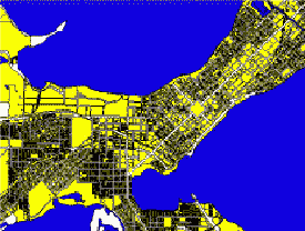
1:35,286—A large scale map of Madison's isthmus.
Do you see where the Capitol Building should be?
Large Scale=Everything looks Large!
Small Scale=Everything looks Small!
4. Larger scale maps show more accurate distances.
When you use more detailed maps, it is easier to follow the actual route and determine the real distance between two points. When you drive somewhere you rarely travel in a straight line. A smaller scale map shows more of the curves and turns you take and can give you a more accurate measurement.
Time Scale
How many years should we show? Is one month enough time?
This information is on a separate page since it is a fairly advanced concept.
Legend
The legend lists the symbols used on a map and what they depict. These symbols should appear in the legend exactly as they are found in the body of the map and be described clearly and fully. Do not treat the legend as an afterthought; it should receive careful attention.
Cartographer
Don't forget to put the map-maker's name on the map! This makes it easier for people who want to find out more about the map to contact you.
Date of production
The meaning and value of some maps—such as those relating to current affairs or weather—are time sensitive. The reader must know when they were produced to gauge whether to trust them. An out-of- date road atlas or city map can make a map-reader really frustrated! Other maps are less sensitive to the passage of time, but the date of production can still be important if, for example, better information becomes available in the period after publication.
Be sure to indicate the date of production for your map, or make sure that it can be inferred from the context in which it is to appear (maps that appear in newspapers, magazines, and journals can be dated in this way). The detail with which you specify the date of production will depend again on the nature of your theme and audience.